Mr. Sala is ocean kayaking from one continent to another. He wants to touch the shore of every continent. We must determine the shortest route in which to touch every single continent. If he rests for 6-8 hours per day and can paddle at 10 miles per hour, we also must figure out how long it will take him.
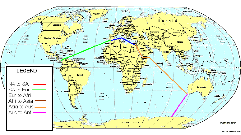
I had Mr. Sala start in the middle of the Panama Canal. That way he could be in North America and South America at the same time. That's the same reason I had him go through the Suez Canal. I chose this path for Mr. Sala's kayak trip:
I Measured the Length of Mr. Sala's Trip Using A Globe
Why I Used A Globe Instead of A Map
The Earth is a sphere, so if you use a flat piece of paper some continents and oceans will not be the right sizes and shapes. For example, if you use a cylindrical projection, like a Mercator projection, only places on the equator will be the right shape and size. (The map above is a modified cylindrical projection.) If you use an azimuthal projection, only one point in the center is accurate. (I used an azimuthal projection to measure the "Distance On Map" below).
In this problem, if you use a map, you can get all your distances goofed up, because the size and shape of the continents and oceans will be incorrect most of the time. This means the distance of Mr. Sala's trip will be wrong.
Comparing The Globe Measurement To A Map
Here are my measurements for Mr. Sala's trip, using a globe and a map:
| Leg Of Trip |
|
|
| N. Amer. to S. Amer. | 0 | 0 |
| S. Amer. to Europe | 4973 | 4798 |
| Europe to Africa | 2210 | 2525 |
| Africa to Asia | 0 | 0 |
| Asia to Australia | 6630 | 7070 |
| Australia to Antar. | 3315 | 2525 |
| TOTAL DISTANCE | 17,128 | 16,918 |
To figure out how long it will take, we will multiply it by 1 hour divided by 10 miles (because that's his rate). That will give us the total number of hours he must travel. Then take the total number of hours times 1 kayaking day divided by 18 hours (that's the number of hours he kayaks each day). So, to cover the distance shown on the map, it will take Mr. Sala a little over 95 days. To cover the distance shown by the globe, it will take Mr. Sala exactly 94 days.
Advice To Mr. Sala
Mr. Sala hasn't been ocean kayaking before. So he'll need some tips, here are some links to give him some:
Oregon Ocean Paddling Society (OOPS) Oops is perfect for Mr. Sala.
Drownproofing in case you fall out.